Mt Dulang-Dulang (2938m) and Mt Kitanglad (2899m) is the second and fourth highest mountain in the Philippines. The traverse is fairly difficult, so an experienced local guide as well as a rope will be needed here.
Friday, November 09, 2012 |
Posted in
Asia,
Hiking,
Latest,
Mountains,
Philippines,
Ultras
|
Read More »
Mount Tapulao (2037m), named High Peak on most maps, is one of the 29 ultra prominent mountains in the Philippines. It's a long hike mainly on an abandoned mining road.
Thursday, October 18, 2012 |
Posted in
Asia,
Hiking,
Latest,
Mountains,
Philippines,
Ultras
|
Read More »
Vatican Hill stands only 75 m tall, but don't underestimate it. This tiny hill is actually one of the most difficult high points in Europe, because of restricted access to the gardens.
Thursday, October 11, 2012 |
Posted in
Country High Points,
Europe,
Latest,
Travel,
Vatican
|
Read More »
I had a few days in Rome to experience the heart of the old Roman empire and to get a well deserved break after a busy week in the Apennine mountains.
Wednesday, October 10, 2012 |
Posted in
Europe,
Italy,
Latest,
Travel
|
Read More »
My time was running out, Monte Velino (2487m) was going to be the crowning end of my unforgettable journey in the Apennine mountains. Salute!
Monday, October 08, 2012 |
Posted in
Europe,
Hiking,
Italy,
Latest,
Mountains
|
Read More »
Monte Vettore (2476m) is a prominent mountain in the Sibillini range. Anyone with a great passion for Tibet and Lhasa will simply love this corner of the Central Apennines.
Sunday, October 07, 2012 |
Posted in
Europe,
Hiking,
Italy,
Latest,
Mountains
|
Read More »
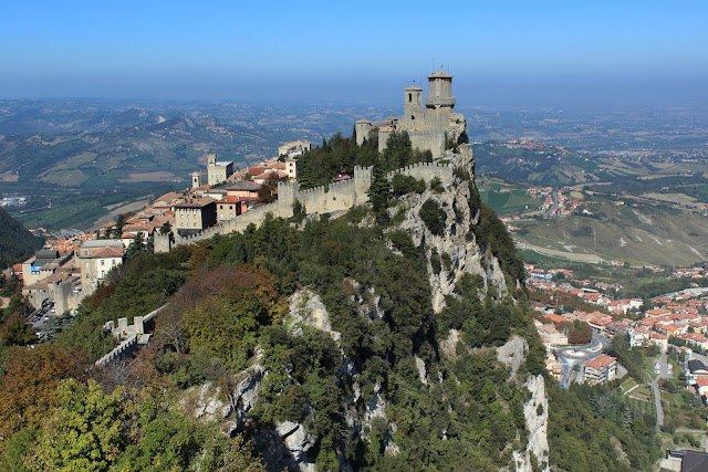
Monte Titano (739m) is the highest hill in the Republic of San Marino and a great opportunity to witness the fake people of high society.
Saturday, October 06, 2012 |
Posted in
Country High Points,
Europe,
Hiking,
Italy,
Latest,
Mountains,
San Marino
|
Read More »
Monte Camicia (2564m) is, because of its spectacular north face, often named the "Eiger of the Apennines". I'm not suicidal so I went for the normal route, which is just a short and easy hike.
Friday, October 05, 2012 |
Posted in
Europe,
Hiking,
Italy,
Latest,
Mountains
|
Read More »
Corno Grande (2912m) is the highest mountain on the Italian Peninsula and I was really looking forward to do a real climb again, not just a simple hike.
Thursday, October 04, 2012 |
Posted in
Alpinism,
Europe,
Italy,
Latest,
Mountains,
Ultras
|
Read More »
Monte Amaro (2793m) is an ultra prominent mountain in the Central Apennines of Italy. The summit is fairly remote from the road, so you are likely to see more wild chamois than people around.
Picking up a rental car in Pescara
I was able to find a really cheap flight from Oslo to Pescara. I paid only 18 Euro (all inclusive) for the 3 hours flight, obviously avoiding most of Ryan Air's excessive fees. At arrival in Pescara I picked up a rental car from Avis, which I already had reserved for 7 days through internet (140 Euro including insurance). Usually you get what you pay, still I was somewhat disappointed when I saw the ridiculously small Fiat 500. I was really worried that its tiny engine would fail to climb the steepest roads in the Apennines.
A pleasant stay in Caramanico Terme
I arrived Pescara in the afternoon, so it was too late to do any major hikes the same day. Instead I was going to have a look around Majella National Park, where Monte Amaro is the highest peak. Leaving the highway west of Pescara, I drove up to a mountain pass, just some few kilometers west of Amaro's summit. Unfortunately the dense afternoon fog obscured everything before I was able to study any direct routes to the summit from this pass.
I drove back down again to Caramanico Terme, which is a really beautiful medieval town with hot springs and fantastic mountain views. It was soon getting dark, so I decided to check into a B&B which set me back 35 Euro. Instead of visiting the hot spring and spa, I spent the major part of the evening on wireless internet searching for the best route up Monte Amaro. I realised that it was not from the pass I had just visited, because you can get substantial higher with a car from the south side (Blockhaus).
The trailhead at Blockhaus
Early next morning I drove up to Blockhaus, which is the most frequently used trailhead for Monte Amaro. I had already uploaded the Garmin road map of Europe to my handheld GPS device, so I had no problems finding my way via numerous small roads from Caramanico Terme. I parked my small Fiat next to a building (refuge) at almost 1900 m.a.s.l, a really ugly and windswept place littered with a dozen of antennas in all kind of shapes and sizes. The paved road actually continues further up, but it's closed for cars due to environmental reasons.
At the start I took a shortcut on my righthand side to avoid the first bend in the road, then I continued walking on the road. The weather was absolutely gorgeous and I could easily see Pescara and the Adriatic Sea far below, as well as Corno Grande (2912m) in the horizon.
Beware of dwarf pines
The road eventually ran out after 2 kilometers where I continued on a grassy trail. I had some troubles identifying the main trail in the grass, because there were a few variations to choose between. To avoid any loss of elevation, I foolishly chose the upper alternative, which eventually got me stuck in a thick belt of dwarf pines. I was fighting my way through roots and branches, before I was able to find an escape route back down to the main trail after 15 minutes of struggle. The horrendous dwarf pines ripped up my trousers and gave me several painful scratches. However, from this point forward, I had no troubles following the main trail. It was a really gentle hike along a fairly level ridge, before I started on the steep and taxing uphills to Monte Focalone.
Wildlife and solitude
Shortly before the summit of Monte Focalone (2676m), I could see Monte Amaro and its easy recognizable red dome on the summit. But it was still far away and a substantial loss of elevation in between. First I descended to the saddle between Monte Focalone and Cima Pomilio, where I spotted a dozen of goat-looking antelopes (Abruzzo Chamois) crossing the trail. I spent a long time trying to catch them on my DSLR camera. After Cima Pomilio (2656m) followed another descent and ascent to Tre Portoni (2657m). But from here it was just a gentle hike towards Monte Amaro (2793m), and no more intermediate summits or ridges to cross.
The 13 km hike from Blockhaus had taken me 3 hours and 45 minutes, and I had only seen two small groups of hikers on the trail, no one aiming for Monte Amaro though. I spent more than half an hour on the summit, enjoying the solitude and nice views, when I realised that I soon have to return to avoid bad weather and nightfall.
Enveloped in a dense fog
Returning the same route to the car took me another 3 hours and most of the time I found myself enveloped by a dense fog. But the trail was easy to follow and I had my GPS as a backup for navigation. The only thing that worried me was the frequent occurrence of afternoon thunderstorms in the Apennine mountains, because I would really be exposed to lightning on such a high route. But the electrical storm didn't start before later, when I was safe inside my car heading for L'Aquila and
my next target, Corno Grande (2912m).
Monte Amaro at EveryTrail
lyngve
0568
72
LOADING PHOTOS FROM THE ALBUM....
Wednesday, October 03, 2012 |
Posted in
Europe,
Hiking,
Italy,
Latest,
Mountains,
Ultras
|
Read More »
Dinara (1831m) is the highest mountain in Croatia and was our last hike on this Balkan marathon tour, something I think both of us were happy for.
Wednesday, September 19, 2012 |
Posted in
Country High Points,
Croatia,
Europe,
Hiking,
Latest,
Mountains
|
Read More »
Maglic (2386m) is the highest mountain in Bosnia-Herzegovina. We chose the direct approach from north, a fairly short climb which was ideal to test out Lars' performance after his severe stomach bug from the day before.
Tuesday, September 18, 2012 |
Posted in
Bosnia,
Country High Points,
Europe,
Hiking,
Latest,
Mountains
|
Read More »
What is the highest mountain in Montenegro still remains a big mystery to us. At least we climbed both Zla Kolata and Dobre Kolata (2 out of 4 candidates) to increase the probability that we had set foot on the highest point in Montenegro.
Monday, September 17, 2012 |
Posted in
Country High Points,
Europe,
Hiking,
Latest,
Montenegro,
Mountains
|
Read More »
Deravica/Djeravica (2656m) is a country highpoint no matter how one defines the territory of Kosovo and Serbia. The previous war and the ongoing struggle to liberate Kosovo from Serbia, makes this a more risky and unstable destination than the rest of Balkan.
Sunday, September 16, 2012 |
Posted in
Country High Points,
Europe,
Hiking,
Kosovo,
Latest,
Mountains
|
Read More »
Mount Korab (2764m) is the highest mountain in both Macedonia and Albania. We decided to climb it from Macedonia even though various sources on internet states that this approach can be prone to restrictions due to border issues and security reasons.
Friday, September 14, 2012 |
Posted in
Albania,
Country High Points,
Europe,
Hiking,
Latest,
Macedonia,
Mountains,
Ultras
|
Read More »
Musala (2925m) is the highest peak in Bulgaria and the entire Balkan Peninsula. But it's not a demanding hike, if the gondola is in operation.
Thursday, September 13, 2012 |
Posted in
Bulgaria,
Country High Points,
Europe,
Hiking,
Latest,
Mountains,
Ultras
|
Read More »
Midzor (2169m) is the highest peak in Serbia outside of Kosovo. While Kosovo is still fighting for its independence, most countries (except Serbia of course) recognise Kosovo as an independent country. So do I.
Wednesday, September 12, 2012 |
Posted in
Country High Points,
Europe,
Hiking,
Latest,
Mountains,
Serbia
|
Read More »
Triglav (2864m) is the highest mountain in Slovenia and a bit more demanding than the average country highpoint in Europe. I was also happy to get some company from Norway.
Tuesday, September 11, 2012 |
Posted in
Alpinism,
Country High Points,
Europe,
Latest,
Mountains,
Slovenia,
Ultras
|
Read More »
Bled is probably the most scenic place in Slovenia and certainly the most touristy. I was just glad that the main tourist season had come to an end before I arrived.
Monday, September 10, 2012 |
Posted in
Europe,
Latest,
Slovenia,
Travel
|
Read More »
It proved very easy to do Kekes (1014m) as a day trip from Budapest. The highest hill in Hungary is according to Wikipedia the third most popular tourist attraction in this country, after Lake Balaton and the Danube.
Friday, September 07, 2012 |
Posted in
Country High Points,
Europe,
Hungary,
Latest,
Travel
|
Read More »
Lviv (Lvov) is a really wonderful city in Ukraine, most recently known for hosting some of the games in the 2012 UEFA European Football Championship.
Wednesday, September 05, 2012 |
Posted in
Europe,
Latest,
Travel,
Ukraine
|
Read More »
Hoverla (2061m) is the highest mountain in Ukraine. The biggest challenge of this mountain is how to get there by public transportation, especially if you don't speak Russian.
Sunday, September 02, 2012 |
Posted in
Country High Points,
Europe,
Hiking,
Latest,
Mountains,
Ukraine
|
Read More »
I have taken thousands of taxis during all my travels around the world, but the bandit of a taxi driver in Ukraine was my worst experience ever with a taxi.
Saturday, September 01, 2012 |
Posted in
Europe,
Latest,
Travel,
Ukraine
|
Read More »
Dealul Balanesti (430m) is the highest hill in Moldova. Nowadays it's even possible to drive all the way to the summit.
Tuesday, August 28, 2012 |
Posted in
Country High Points,
Europe,
Hiking,
Latest,
Moldova,
Mountains
|
Read More »
Moldoveanu Peak (2544m) is the highest mountain in Romania, and most commonly done as a multi-day hike. But my schedule in Romania was tight, so I decided to do it in one LONG day.
Friday, August 24, 2012 |
Posted in
Country High Points,
Europe,
Hiking,
Latest,
Mountains,
Romania,
Ultras
|
Read More »
Skruven (1584m) is not as famous or prominent as many of the other mountains at Sunnmøre, but it's certainly the most interesting climb around Hellesylt.
Wednesday, July 25, 2012 |
Posted in
Alpinism,
Europe,
Latest,
Mountains,
Norway
|
Read More »
The annual Sinulog Festival in Cebu City is one of the biggest events in Philippines. But how would it be to celebrate it in Maasin City?
Sunday, January 15, 2012 |
Posted in
Asia,
Latest,
Philippines,
Travel
|
Read More »
The Hanginan Trail is a popular hike in the green hills behind Maasin City. Emily has done this hike several times before, while this was the first time for me.
Sunday, January 08, 2012 |
Posted in
Asia,
Hiking,
Latest,
Mountains,
Philippines,
Travel
|
Read More »